Traffic and Area Studies (Updated 10/19/2022)
Identify potential Committee involvement related to the following:
- Community reported traffic volume and traffic safety concerns and issues.
- Understanding significant current and planned roadway construction (Corridor Studies) and assess potential impact to the affected communities
- Understand the impact on traffic due to significant land development projects.
- Understand the published traffic statistics such as volume, accidents, and deaths.
- Understand significant current and planned traffic safety initiatives, such as adding/removing cameras or increased/decreased police presence, and assess potential impact to the affected communities.
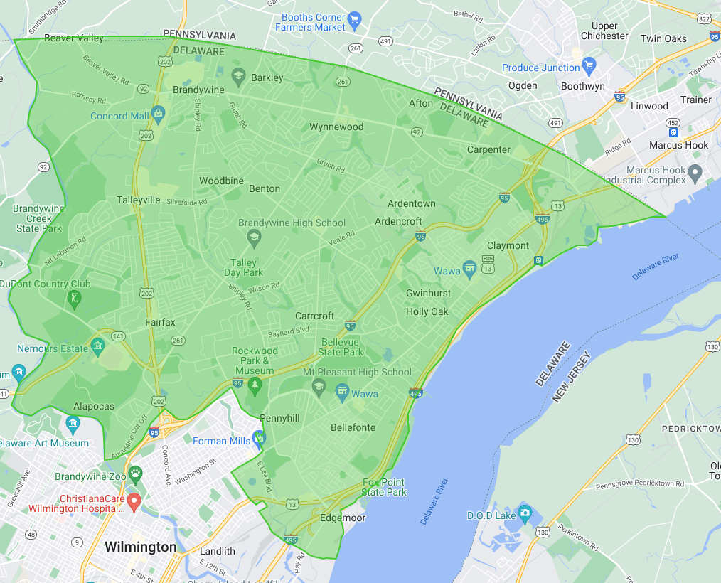
The Roads Committee will focus on roads within the Brandywine Hundred Boundary
Brandywine Hundred is that portion of New Castle County that lies north of the Christina River and east of Brandywine Creek, excepting that portion in the south included in Wilmington Hundred. Its northern boundary follows a portion of the 12 mile arc that boarders PA.

Do you have a serious concern about the traffic or road construction in Brandywine Hundred area?
Email our ROADS COMMITTEE CHAIRPERSON Rick Buckmaster detailing your concerns. We will let you know what CCOBH might be able to do to provide you with assistance in resolving your concerns.
Road Construction Plans in Brandywine Hundred
DelDOT Projects Portal
Planning and Design
Foulk Road Reconstruction and Reconfiguration The primary purpose of this project is to reconstruct the failing pavement and remedy drainage issues. A concept is being studied that would reconfigure the road to create space for a continuous sidewalk, bicycle lanes, a center left turn lane, and one lane of travel for each direction.
Construction Start Date: TBD
Construction End Date: TBD
Project Update: A public workshop was held on July 12 to gauge feedback on a proposed roadway reconfiguration concept. Workshop materials are available online for those who could not attend. We had 241 people attend the in-person public workshop and received a total of 166 comments prior to, during, and after the workshop. As noted at the workshop, while our design team presented a concept plan, our goal was to solicit public input on this plan. No final decisions have been made at this time. Based on public input and coordination with area legislators, we are going back to the drawing board and will look to develop options to address the various concerns expressed. We plan to reengage the community in early 2023.
Augustine Cut Off Bicycle Network Improvements
This project will explore options for bicycle and pedestrian improvements along Augustine Cut Off that will link the state’s two largest population centers, the City of Wilmington and Brandywine Hundred, by connecting the greater Blue Ball/US 202 Pathway system to Trolley Square and the Brandywine Park trail network.
Construction Start Date: TBD
Construction End Date: TBD
Safe Routes to School, Wilmington Montessori
Bicycle and Pedestrian Improvements new Wilmington Montessori School on Harvey Road
Construction Start Date: Spring 2023
Construction End Date: Summer 2023
Old Brandywine Village Streetscape Improvements Phase II
This project consists of modifying curb lines, reconstructing curb ramps, upgrading or installing piano key crosswalk striping, installing lighting and landscaping. This project will be a continuation of previous streetscape improvements along Concord Avenue.
Construction Start Date: Fall 2023
Construction End Date: TBD
Under Construction
Claymont Station
This project will be for the design of a new Claymont commuter rail station integrated with the redevelopment of a former industrial site into an office/commercial complex. The new station will provide full ADA compliance and enhanced passenger facilities.
Construction Start Date: Summer 2019
Construction End Date: Fall 2023
This project was awarded and advanced construction efforts started in June 2019. Since this project is a Design Build, the team is still working on many design efforts. Work along Philadelphia Pike has been on-going. Major construction activities are currently on-going. Construction is anticipated to be complete in the Fall of 2023.
Claymont Station Project Website
–there are no upcoming Public Meetings currently scheduled for this project. There are currently no Closures or Restrictions close to this project!
Stonework for Bridges 1-022 and 1-525 on Shipley Road–Project Partially complete
Adding stone masonry and aluminum railings to the existing bridges 1-022 and 1-525. Construction started on July 18. The stonework for the parapets is experiencing material delays. As a result, there will be a pause on the contract until later this year at which time the capstone and handrail will be installed over a 2-week period. We had anticipated completion by the end of the year, but temperatures may not allow for this work to occur until spring, depending on when the capstone arrives.
Construction Start Date: Spring 2022
Construction End Date: Fall 2022
Completed Construction
First State National Historical Park (NHP) Pedestrian Safety Project with the Federal Lands Access Program (FLAP) grant to improve bike and pedestrian road crossings for the NHP trail system.
Construction Start Date: Spring 2022
Construction End Date: Spring 2022
Rockland Road Roadside Safety Improvements – This project involves the construction of a moment slab with barrier or guardrail with retaining wall along Rockland Road.
Construction Start Date: Summer 2024
Construction End Date: TBD
Stonework for Bridges 1-022 and 1-525 on Sharpley Road–Project partially complete Adding stone masonry and aluminum railings to the existing bridges 1-022 and 1-525.
Construction Start Date: Summer 2022
Construction End Date: Fall 2022
Safe Routes to School Claymont Elementary Phase 2 ABicycle and Pedestrian Improvements Near Claymont Elementary School
Construction Start Date: Winter 2021/2022
Construction End Date: Fall 2022
Traffic Statistics
DelDOT – Integrated Transportation Management Program
From this website there are several informative links.
Traffic Counts– this is an interactive map. Click on a section of the road and it provides the last 10 years Average Annual Daily Traffic (AADT)
